

The current winter storm is jaw dropping from many perspectives. As frigid air continues to plunge into the continental United States, winter storm watches or warnings cover much of the country. However something caught my eye as I scanned the weather radar on the morning of February 15th, 2021 – the occurrence of “thunder sleet.” I know that sounds like a superhero or video game icon, but it is a actually a meteorological “thing.” I will explain.
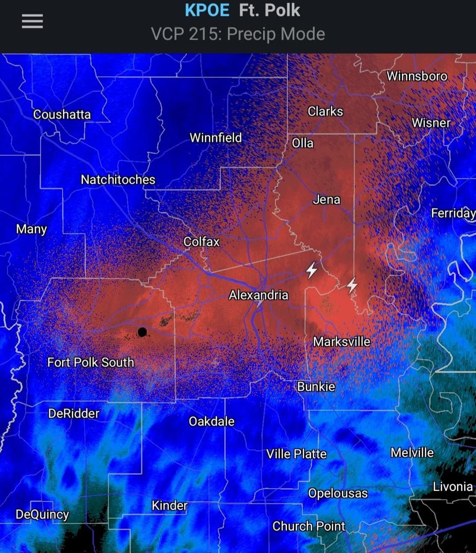
Lightning embedded in a region of likely sleet indicates Thunder sleet on February 15th, 2021.
Marshall Shepherd and RadarScope App
The radar image above shows precipitation depiction. Blue areas are generally considered to be snow, and pinkish areas are likely a mix of snow and sleet. Many people are familiar with “thundersnow.” If you watch The Weather Channel, my friend Jim Cantore’s live shot reactions to it are legendary. The American Meteorological Society (AMS) Glossary of Meteorology defines thundersnow as, “a compound of the words ‘thunder’ and ‘snow’ used informally to describe an observation of snow at the surface that occurs with lightning and thunder.” Lightning (which causes thunder) is typically associated with an atmosphere sufficiently unstable (the air easily will rise) to support convective cells.

Definition of Thundersnow
NWS
Thundersnow is very rare in the United States. A 2009 paper published in the journal Weather stated that thundersnow only happens about 0.07% of the time. Thunder snow is rare because the mix of lift and instability required for lightning is simply more common in warm season months. Additionally, snow is a fluffy and absorbs sound which makes thunder more difficult to hear. However, I suspect most people have heard of thundersnow. The term “thundersleet” may be less familiar. In fact, I could not find an entry for it in the AMS Glossary.
Thundersleet (an example can be heard here) is conceptually similar to thundersnow. Convection is causing lightning. The main difference is sleet is falling rather than snow. Southerners and people in the Mid-Atlantic (I-95 corridor) are familiar with mixed precipitation events. In the U.S., most rainfall starts as snow in the cloud. If the temperature is below freezing all the way down to the surface, it remains as snow. However, if it falls through a region of temperatures above 32 degrees F, it melts and falls as rainfall. In some circumstances (like this morning in the Deep South), there are places with a lower atmosphere cold enough to support snow. There are other places where there is melting followed by a refreeze to sleet or ice pellets before hitting the ground. If the air is above 32 degrees F but below freezing at the surface, the rain freezes at the surface (freezing rain or glaze).

Why rain, snow, sleet, or freezing rain falls.
NWS
All of these things are happening in the South as I write this article. Dr. Brad Johnson is a meteorologist and professor in the Department of Geography at Florida State University. Johnson’s research has explored how warmer urban environments can modify the type of frozen precipitation that falls to the ground. This weekend Dr. Johnson tweeted the graphic below and said, “Never have I seen the entire state of Texas in a Winter Storm Warning.” I am not surprised that Johnson, a former doctoral student of mine, is monitoring the storm. He is a Weather Geek like me, and he is from Baton Rouge, Louisiana, a place currently experiencing mixed precipitation. Johnson’s text to me this morning sums this storm up nicely, “I’ve been scrolling through radar and weather observations for 20 minutes. What a storm this is.”
What’s interesting (and of concern) is that the forecast models and the NOAA Weather Prediction Center call for several rounds of this type of weather in the Deep South over the coming days. Be careful.

Winter storm watches and warnings posted on February 14th, 2021.
NWS
This article is auto-generated by Algorithm Source: www.forbes.com